YouTube Flying Videos by Jan
Nademlejnsky
>> HOME <<
January 5, 2026
| 2026 | 2025 |
2024 | 2023 | 2022 | 2021 | 2020 | 2019 | 2018 | 2017 | 2016 | 2015 | 2014 | 2013 | 2012 | 1974-2010 | Video Index |
You could search this page by
pressing Crl F
| BC Fires | My Tubespace |
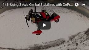 141. Using
3 Axis Gimbal Stabilizer, with GoPro Bar Camera, Dec 27, 2016
141. Using
3 Axis Gimbal Stabilizer, with GoPro Bar Camera, Dec 27, 2016
The camera view does not look too impressive, unless
it would be placed up front and facing back or the other way around. The
stabilizer was sometimes "hunting" around vertical axes at about +/-
3 deg, which is annoying.
Stabilizer FY-WG X3 has 3 gyroscopes and could be
mounted on helmet too. I used "GoPro Hero3+ Silver" camera with this
stabilizer.
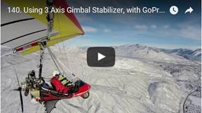 140. Using
3 Axis Gimbal Stabilizer, with GoPro Wing Camera, Dec 27, 2016
140. Using
3 Axis Gimbal Stabilizer, with GoPro Wing Camera, Dec 27, 2016
The camera view looks interesting, but there are some
negatives too. The stabilizer was sometimes "hunting" around vertical
axes at about +/- 3 deg, which is annoying.
Stabilizer FY-WG X3 has 3 gyroscopes and could be
mounted on helmet too. I used "GoPro Hero3+ Silver" camera with this
stabilizer.
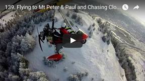 139. Flying
to Mt Peter & Paul and Chasing Clouds, Dec 10, 2016
139. Flying
to Mt Peter & Paul and Chasing Clouds, Dec 10, 2016
After about 10 days of suddenly cold weather we got
break. It was sunny, -5C and ground just covered with show. I like these
conditions, because everything looks nicer from the air. The
I flew over bunch of clouds above the Mara Hill. I had
fun there. I even forgot that my fingers are really getting numb. It was good
day
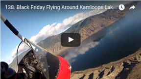 138. Black
Friday Flying around Kamloops Lake, Nov 25, 2016
138. Black
Friday Flying around Kamloops Lake, Nov 25, 2016
Everybody rushed to spent money on Black Friday
specials, but I went for Fun Friday flying tour. It was perfect day to fly in
this beautiful blue sky over our region spectacular scenery. It was another
first for me, because the north side of the
 137. Flying
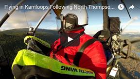
in Kamloops Following North Thompson River to McLure, Nov 16, 2016
137. Flying
in Kamloops Following North Thompson River to McLure, Nov 16, 2016
A friend asked me to take some pictures in McLure
area. The weather just turned to very good from gloomy a few minutes before. I
jumped into my trike and flew in the coldest day of the year to North. The sky
was beautiful, but just 3 km before the target area, the clouds closed in. The
photo conditions were the worst possible in very big contrasts. Later I learned
that I took pictures of the wrong area. Oh, well, at least I had some fun.
Note: All my videos are taken in 4x3 (1280x960). This
is default setting on all GoPro Cameras. This wide angle of view in vertical
direction is perfect setting for skiing, snowboarding, flying, water sports,
because it captures max possible angle in vertical direction. It shows all from
sky to skis or from sky to what is under me when flying. 16x9 format is cropped
out strips from the top and from the bottom of the existing captured
information, which does not make any sense. These days everybody is going nuts
about 16x9 because all TV are in more less 16x9 format. iPads are in 4x3 format
so my video covers full screen.
My posted videos are converted by YouTube to 16x9, but
1280x720 from original 1280x960. The resulting video has lower resolution then
the original with black strips on left and right. My original video is shrunk
from 1280 x 960 =1228822 pixels per frame to 960 x 720 = 691200 which is only
56% of the original frame resolution. I am not happy about it.
I saved another version of this video in the 16x9
format while I padded sides of the frames with black strips myself while
maintaining the vertical resolution of 960 pixels. I converted it from 1280x960
to 1920x1080 by default Corel VS X9 format for my video. I will see if this
makes any difference on YouTube: It was even worse the before. YouTube resized
it to back 1280x720. It did not work as I thought it would.
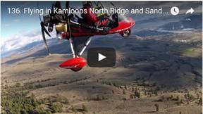 136. Flying
in Kamloops North Ridge and Sand Bars, Nov 14, 2016
136. Flying
in Kamloops North Ridge and Sand Bars, Nov 14, 2016
It was beautiful day, perhaps the last of relatively
warm autumn days. Fluffy clouds created beautiful spotty patterns on the rolling
hills. I really like these days.
I used my third GoPro camera on the helmet, but the
result is disappointing. There is too much head movement. I wanted to use it
mainly to maintain horizon level in the turns, which is how it should be. The
airplane is tilting while horizon is level. Even in commercial movies the
airplane is horizontal, but the background is tilting, which is not normal.
I will not use head cam anymore. The next time, I have
to find some camera exciting location to mount it.
 135. Flying
in Kamloops Following South Thompson River East, Nov 6, 2016
135. Flying
in Kamloops Following South Thompson River East, Nov 6, 2016
It looked like perfect day for flying: sunny, very few
clouds and no wind. I wanted to fly to Chase, but as soon as I crossed the North
Thompson Rive the turbulence started with wind shifting 180 deg in few minutes.
It was no fun flying, because it was getting continually more intense. As I did
not want to push my luck, I decided to head home. I hope next time
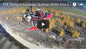 134. Flying
in Kamloops to Rose Hill Rd Area and Sand Bars, Oct 22, 2016
134. Flying
in Kamloops to Rose Hill Rd Area and Sand Bars, Oct 22, 2016
It was nice day to go flying, so I vent. I explored
the area east of Knutsford and found some beautiful places. I used my all road
motorcycle in the afternoon to take also ground pictures, but all roads and
access were private. It was very disappointing.
 133. Flying
in Kamloops to North Ridge and South Thompson, Oct 11, 2016
133. Flying
in Kamloops to North Ridge and South Thompson, Oct 11, 2016
It was cold (8C) sunny morning, total contrast to hot days
just 3 weeks before. I was flying about 10 minutes, when I realized that I left
my camera on the back seat. I was not sure if I will see my popular camera ever
again as there is nothing preventing it from falling out of sky. I turned very
gently to prevent camera to slip out. Luckily, I found it still on that seat
when I landed.
I took off again to North Ridge with intend to fly
about 20 km north. The heavy rolling clouds right in my intended path scarred
me, so I turn back south, following the
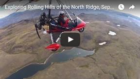 132. Exploring
Rolling Hills of the North Ridge, Sep 10, 2016
132. Exploring
Rolling Hills of the North Ridge, Sep 10, 2016
I was filming my contribution to Canada in a
Day in the morning, but the sky was not too impressive. Finally the
sun showed up and with it the flying mood level went up too. I explored
beautiful area of the Kamloops North Ridge with rolling hills and many small lakes.
The surrounding areas of the lakes (slews) turn purple as they drying out in
this time of the year. It is very beautiful there.
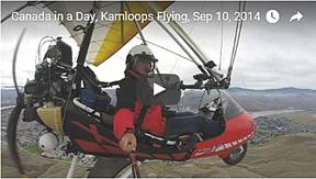 131. "Canada
in a Day", Kamloops Flying, Sep 10, 2014
131. "Canada
in a Day", Kamloops Flying, Sep 10, 2014
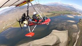
This is short video of my story as Canadian. It is my
contribution to CTV campaign to collect as many videos as possible from people
documenting what they are doing on Sep. 10, 2016
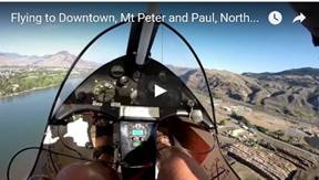
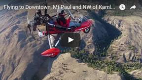 130.
Flying to Downtown, Mt Paul and NW of
Kamloops Lake, Sep 4, 2016
130.
Flying to Downtown, Mt Paul and NW of
Kamloops Lake, Sep 4, 2016
It looked like almost perfect flying afternoon. I
received few kicks from the Mother Nature right at the start, but eventually
the weather settled down to let me enjoy my time in the air. I flew to downtown
and then north around Mt Paul, where I was knocked down very good be a
downdraft. The rest of the flight following the North Ridge west was just pure
joy. Beautiful, blue sky with heave and interesting clouds made it even more
enjoyable. I flew farthest west then before to have that magnificent view of the
I ended my trip over the river sand bars which are developing very nicely. The river level is dropping steadily by this time of the year and exposing intricate forms of newly created sand bars. It is really joy to fly over and to have this rare opportunity to see it like that.
 129.
Flying to Downtown, Mt Peter and Paul,
North Ridge and Sand Bars, Aug 20, 2016
129.
Flying to Downtown, Mt Peter and Paul,
North Ridge and Sand Bars, Aug 20, 2016
Just needed my flying fix. One hour flying in
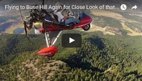 128. Flying
to Buse Hill Again for Close Look of that Beauty, Aug 12, 2016
128. Flying
to Buse Hill Again for Close Look of that Beauty, Aug 12, 2016
After my previous flight to Buse Hill area in Aug 1,
2016, I drove my terrain motorcycle there to explore that beautiful region. I
was so impressed that I decided to fly there again for close look. I wish the
camera could capture exactly what human eye can see. I also tried my hand GoPro
strap for some more interesting camera angle views. The result was
disappointing, because the camera is too loose-fitting resulting shaky videos.
The hand signals do not indicate that I got mad; they are used to synch my 3
GoPro cameras.
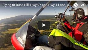 127. Flying
to Buse Hill, Hwy 97 and Hwy 1 Loop, Aug 1, 2016
127. Flying
to Buse Hill, Hwy 97 and Hwy 1 Loop, Aug 1, 2016
It was very calm morning, unusually cold at 15C
compare with previous days at 25C. This was second time trying to fly east
across
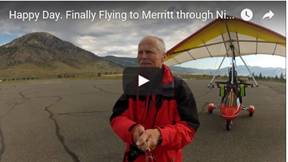 126. Happy
Day. Finally Flying to Merritt through Nicola Valley, June 29, 2016
126. Happy
Day. Finally Flying to Merritt through Nicola Valley, June 29, 2016
I finally made it. The weather always won over my
bravery during my many unsuccessful attempts to fly through
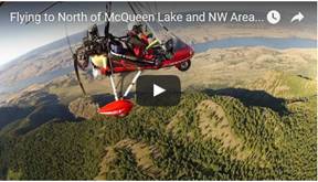 125. Flying
to North of McQueen Lake and NW Area of North Ridge, June 26, 2016
125. Flying
to North of McQueen Lake and NW Area of North Ridge, June 26, 2016
It was new area for me to fly to, which is not very
engine-out friendly. It is beautiful like all this region of BC. It was one of
the most enjoyable flights, without turbulence.
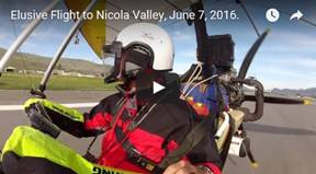 124. Elusive
Flight to Nicola Valley, June 7, 2016
124. Elusive
Flight to Nicola Valley, June 7, 2016
Another attempt to fly through the
I took off from
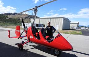 123. My
Dream Gyrocopter Flight Penticton - Oliver - Osoyoos - Penticton, May 30, 2016
123. My
Dream Gyrocopter Flight Penticton - Oliver - Osoyoos - Penticton, May 30, 2016
My big, about 45 year old dream to owe and fly a gyro
almost fully materialized in
So I just relaxed and enjoyed very good instruction
flying from Mark Humbke, long time gyro flyer. It was actually my second gyro
flight. The first attempt to get gyro license was in 1999 when I took my tent
and check book to
My intent was to stay there until I have gyro license.
My 20 min intro flight in RAF gyro was not what I expected. I did not like that
screaming engine at 7,800 rpm behind my back and extremely sensitive control. I
could not control it and I was airsick like dog. I bought 6 month old Ford
Taurus station wagon instead. I still have this car with only 100,000 km and
like new.
The flight in MTO Sport by Air Pro Gyro, made in
 122. Kamloops
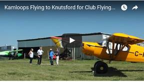
Flying to Knutsford for Club Flying BBQ, May 14, 2016
122. Kamloops
Flying to Knutsford for Club Flying BBQ, May 14, 2016
Blue sky, cold(er) morning and no wind is perfect
combination for some serious turbulence. I flew to Knutsford for our flying
club annual BBQ. The air was bumpy but not too bad. Landed safely at Knutsford,
had my hot sausage, and watch some planes still arriving. It was perfect day to
be outdoor with sun cooking in full force. I knew it would be challenge to fly
back down to airport valley. I was not disappointed in my assessment. It was
kicking like wild horse down to the hot runway radiated the heat right into my
face. Overall, it was good day.
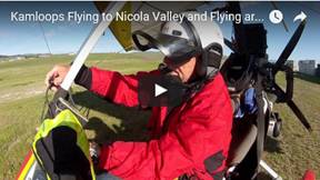 121. Kamloops
Flying to Nicola Valley and Flying around Clouds, May 13, 2016
121. Kamloops
Flying to Nicola Valley and Flying around Clouds, May 13, 2016
I attempted several times to fly through
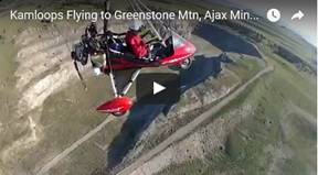 120. Kamloops
Flying to Greenstone Mtn, Ajax Mine, Knutsford, Downtown and Tranquille Farm,
May 5, 2016
120. Kamloops
Flying to Greenstone Mtn, Ajax Mine, Knutsford, Downtown and Tranquille Farm,
May 5, 2016
I took off early morning to prevent any
 119. Chasing
Clouds, Kamloops, Apr 22, 2016
119. Chasing
Clouds, Kamloops, Apr 22, 2016
After many days of very hot weather we received some
rain. The air was loaded with evaporated moisture with many beautiful, layered
clouds over and around high mountain peaks. I could not miss this rare
opportunity to fulfill my childhood dream to jump and play in this fluff. That
morning the weather was almost sunny and no wind. I had fun by flying close,
beside and above those clouds, but still did not dare to fly through.
I checked also the
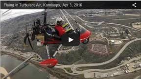 118. Flying
in Turbulent Air, Kamloops, Apr 3, 2016
118. Flying
in Turbulent Air, Kamloops, Apr 3, 2016
The weather was good, practically no wind and overcast
sky which usually brings more stable air for flying. Well. I was wrong. I felt like
riding on wild horse, especially around downtown and Mt Paul. I had hard time
to judge the wind direction, because it was changing constantly in 180 deg in
different elevation layers. Originally I wanted to fly over the Mt Peter and
Paul to video wild horses which I could see from a distance. I gave up on that
idea, because I could not judge if I am on up or down wind of the mountain.
Eventually I flew back in not very pleasant bumps and stayed over the
 117. Kamloops
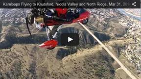
Flying to Knutsford, Nicola Valley and North Ridge, Mar 31, 2016
117. Kamloops
Flying to Knutsford, Nicola Valley and North Ridge, Mar 31, 2016
It was just another beautiful day to go flying. Flew
over downtown, Knutsford airfield and intended to fly through
 116. Kamloops
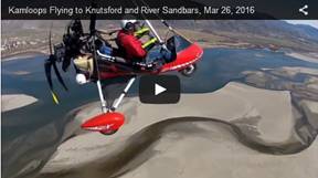
Flying to Knutsford and River Sandbars, Mar 26, 2016
116. Kamloops
Flying to Knutsford and River Sandbars, Mar 26, 2016
I was asked by someone to take video of the
The weather conditions looked good and the wind speed
forecast was low. It showed very quickly that this was not the case. The air
was very turbulent with strong variable wind from south. But I had commitment
to fly over my photographer at Knutsford, so I pushed forward. I made several
passes to pose for the camera and eventually landed for few minutes at
Knutsford. Since I did not like the horizontal wind sock, I decided to head
back while it is still flyable. I flew back towards the airport following the
river while taking pictures and video of the sandbars.
 115. Kamloops
Flying to Take Pictures of Sandbars, Mar 26, 2016
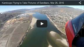
115. Kamloops
Flying to Take Pictures of Sandbars, Mar 26, 2016
I was asked by someone to take video of the
I took video by two cameras and pictures from the
rivers junction up to delta of
 114. Kamloops
Short but Rough Flight, Mar 14, 2016
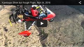
114. Kamloops
Short but Rough Flight, Mar 14, 2016
It looked like perfect flying day, but it was not.
First it was raining a bit, but no cloud around. I turned from downtown to
north following the river up to golf course. The air became very turbulent. I
was bounced like yoyo, so I decided to take short cut over the North Ridge back
to the airport, but it did not want to move. At one point my control bar was
pulled from my hand and into the turn, because my left wing got into updraft. A
year ago or so I would totally freak out, but I am getting more used to these
funny weather phenomena.
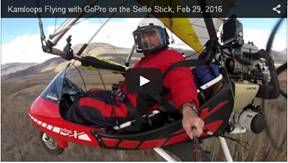 113. Kamloops
Flying with GoPro on the Selfie Stick, Feb 29, 2016
113. Kamloops
Flying with GoPro on the Selfie Stick, Feb 29, 2016
The perfect weather continued so I decided to go for
second flight. I mounted GoPro camera on telescopic hand held selfie stick. I was
hoping for some interesting shots while "steering" with one hand and
fiddling with camera with the other hand. I chose the sand bars on
I was particularly after the video and pictures while
in turn. Normally camera does not take true representation of reality, if the
camera is fixed to the plane. The plane stays horizontal, but the actual
horizon in background is tilted. While flying I tried to rotate camera so that
it is horizontal to the actual horizon. It is not always easy to do, because I
cannot watch the camera 100% of time while flying. I think I took some decent videos
and pictures from the screen shots.
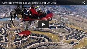 112. Kamloops
Flying to See Wild Horses, Feb 29, 2016
112. Kamloops
Flying to See Wild Horses, Feb 29, 2016
It was one of those "Must-Fly-Days". The
weather was perfect for whatever doing outside, but especially to fly. I
decided to fly pack to SE of Mt Peter to see and video the wild horses again. I
flew there on Feb 6, but my GoPro did not work so I flew there again.
Unfortunately the horses were scattered all over and especially on the downwind
slope of the ridge. The snow was gone so they have no reason to stay down on
bared land. I made several passes around them and the "meadow" and on
the top of Mt Paul. I was also very close to soaring eagle north of the
airport. I tried to follow it, but I had no chance with my 65 Hp engine versus
the perfectly natural creation of the eagle. It was fun.
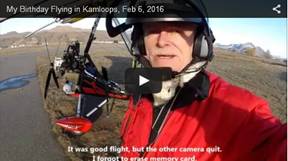 111. My
Birthday Flying in Kamloops, Feb 6, 2016
111. My
Birthday Flying in Kamloops, Feb 6, 2016
This was my 69th birthday, which is frightening and
unfair. It is the last year when I will not be in seventies. Regardless, it was
very good weather to go flying. My original intend was to fly to Harper
mountain ski hill, but I did not find it. I stayed in
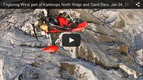 110. Exploring
West part of Kamloops North Ridge and Sand Bars, Jan 24, 2016
110. Exploring
West part of Kamloops North Ridge and Sand Bars, Jan 24, 2016
The weather was perfect for flying. I decided to
explore the mountain area north of
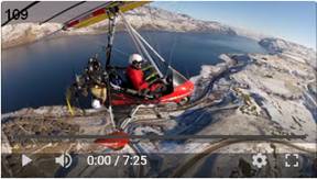 109. Flying
from Kamloops to Tobiano, Jan 20, 2016
109. Flying
from Kamloops to Tobiano, Jan 20, 2016
It was absolutely perfect day to go flying. I just
installed engine electric carburetor heaters to prevent icing of the
carburetors. I am very well experienced with carb icing, but it was not a big
deal when flying in
The carb icing is much more dangerous in
The air was very smooth so it was pleasure to fly in
+5C and blue sky weather. Flew west over Tobiano golf course and residential
area situated on the south side of
 108. Flying
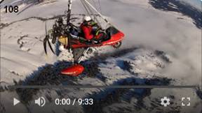
from Kamloops to Ajax Mine and Nicola Valley Clouds, Jan 20, 2016
108. Flying
from Kamloops to Ajax Mine and Nicola Valley Clouds, Jan 20, 2016
The weather was so perfect that I could not waste it. I
decided to explore Ajax Mine area, which is very often in the news because of
the "pro and against" mine issues. I took many pictures from low
level and 6,000'. When at 6,000' I noticed further south that
The west side from intersection of hwy 5A and Campbell
Creek Rd was 100% in clouds and the east side was clear with cloud transition
by the intersection. I never had seen something like this and especially not
from the air. I took a lot of pictures while flying across the valley above
those clouds. The sundog was leading me on my NE side when flying back. I had
very strong urge to burry myself in those clouds, so only my head and the wing
would be above them. I chickened out. I had no idea how this would influence my
flight and I did not want to take any chances.
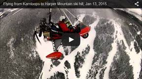 107. Flying
from Kamloops to Harper Mountain ski hill, Jan 13, 2016
107. Flying
from Kamloops to Harper Mountain ski hill, Jan 13, 2016
Plus 5C was inviting temperature to fly in snow
covered